A new White House dashboard aims to help communities confront climate risks
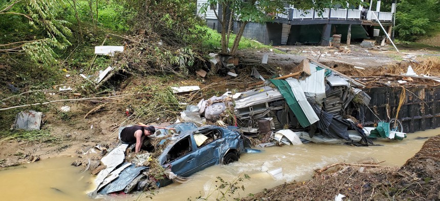
Photo taken on July 30, 2022 shows a house and vehicles destroyed by heavy rain-caused flooding in Central Appalachia in Kentucky, the United States. Dozens of people died as a result of the flooding. Wang Changzheng/Xinhua via Getty Images


 By
Molly Bolan
By
Molly Bolan
The just-launched federal website provides a range of information around extreme weather and natural disasters.
As wildfires, drought and flooding continue to batter swaths of the U.S., the Biden administration launched a new tool on Thursday to help communities prepare for extreme weather.
The Climate Mapping for Resilience and Adaptation portal is an online dashboard that provides real-time and location-specific information about extreme weather threats. It features an interactive map that offers hazard-specific information, such as how many personnel are responding to a particular wildfire or what kinds of flood alerts have been issued in a certain community.
The website, created in partnership with the National Oceanic and Atmospheric Administration and the Interior Department, also shares projections for future weather threats. With the portal’s assessment tool, users can hone in on specific counties, tribal lands or census tracts and learn what weather hazards might look like in the coming decades up to 2099. Information about climate-resilient building codes is also available.
Besides climate data, the portal identifies disadvantaged communities that could be eligible for programs like Biden’s Justice40 Initiative, which aims to direct federal resources to areas disproportionately harmed by climate change and other environmental problems.
“We wanted to build a portal that is science-based, pulling together the best data on impacts that communities have historically faced, what is happening right now, and perhaps most importantly, what the future may hold,” said David Hayes, special assistant to the president for climate policy, during a press conference on Thursday.
From heat waves in California to flooding in Kentucky to droughts in New England, extreme weather has devastated communities this summer. And as the global temperature continues to rise, those threats are expected to become more severe and frequent, experts have said.
NOAA has tracked climate and weather disasters since 1980 that result in over $1 billion in damages or costs. Since then, the number of these events has quadrupled.
In the 1980s, there were on average three disasters over $1 billion each year, costing about $20 billion annually, explained NOAA administrator Rick Spinrad. In the 2010s, that jumped to 13 disasters for an average cost of $92 billion each year.
The new portal, also called CMRA (pronounced “camera”), goes beyond data to share resources about federal funding opportunities, case studies of how communities are navigating climate threats, and information about other federal policies.
CMRA was developed by the software company Esri. Funding for the project came through the infrastructure law Biden signed last year, according to the company.
At Thursday’s press conference, Phoenix Mayor Kate Gallego described some of the weather her city has experienced since she was elected in 2019, including extreme heat and flash flooding.
“It is so valuable for us to be able to have a tool like CMRA where we have all of the best scientific data out there,” Gallego said.
While CMRA provides an overview of multiple hazards, the federal government has other online tools, such as Heat.gov and Drought.gov, that provide more in-depth information about specific threats, Hayes said.
Molly Bolan is the assistant editor for Route Fifty.
NEXT STORY: Dr. Fauci to Young Scientists: Follow the Science and ‘Stay out of Politics’